ECDIS Archives - SHIP IP LTD

Manoeuvring is the ability of a vessel to turn towards the port or starboard side using the steerage force stemming from the turning of the rudder aft based on diverse requirements.

These requirements can be anything like maintaining or changing its desired course of travel, trying to steer clear of an obstruction underway, or approaching a port or dock.

Manoeuvring is a broad topic in naval architecture or vessel sciences and has been a matter of serious discussion and research for years. Many of us are also aware of the manoeuvring trials that take place to assess the turning abilities of a vessel.

Before discussing the pivot point of a vessel, it is crucial to revisit a ship’s ‘turning circle’ manoeuvre briefly.

A turning circle manoeuvre is when the vessel constantly turns towards a particular direction such that it completes or tends to complete a full circle after some time and returns to its origin or starting point.

This is a common aspect of transportation, starting from vehicles like cars or two-wheelers. Similarly, a turning circle is achieved for vessels by simply applying the constant rudder moment towards a particular side.

For example, by applying the rudder angle towards the port side, a vessel turns leftwards and essentially tends to complete a turning circle in an ‘anticlockwise sense.’ Likewise, by applying a rudder angle towards the starboard, the vessel tends to achieve a turning circle in a ‘clockwise sense.’
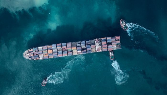
turning circle

Simply put, a turning circle is nothing but a vessel turning in a particular direction. The constant turning moment from the rudder is applied for a fair amount of time to develop a motion in a circular trajectory or path.

Hence, we can all say that when a vessel turns towards a particular side, even for less time, it marks the beginning of the turning circle phenomena. The turning tendency is stopped whenever the rudder is re-aligned, and the vessel re-orients itself to the new direction or course.

Other kinds of nuances and physical phenomena are involved in this. For instance, for a starboard turn, during some initial moments, the vessel tends to drift slightly towards the port side before re-orienting towards the intended starboard direction and vice-versa. This is due to the interplay of some hydrodynamic phenomena.

Moving back to the physics of turning, there are essentially three phases of turning:
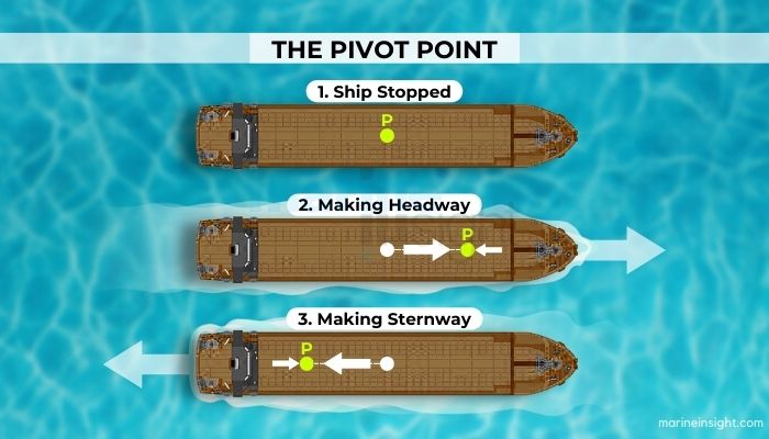
phases of turning - Pivot Point - 1

i) The first, where the rudder force is applied, the vessel tends to initially drift towards the other side and finally attains an equilibrium of forces and moments involved in turning towards the desired course.

ii) the second phase, where the vessel is at 90 degrees from its original direction of heading, and the moments from the induced one of the rudder and the hull are in a state of mutual equilibrium. During this stage, the centrifugal force also comes into action, keeping the vessel oriented towards the geometric centre of the circle it traces or tends to trace.

iii) In The third phase, where a steady state is achieved, the trajectory becomes fixed with a constant radius, and all external forces become virtually non-existent, with the hull moment becoming the dominant one exceeding the induced moment of the rudder.

Now, whenever a vessel is in a state of turn, irrespective of whether it completes a turning circle, the turning takes about a point of action. As we know from the physics of rotation, all bodies in a state of rotatory motion turn about to a fixed point within the geometric limits of the body.

What is a pivot point of a vessel?

This is the same for vessels, where during stages of turning, the vessel’s turning moment acts about a definitive point of action, which lies on its centre-line, somewhat towards the fore-end or aft end. This kinematic point of action is known as the pivot point of a vessel

In simple words, it can also be imagined as the point of rotation of a vessel. Now, since the hull is never a regular-shaped body, this pivot point is never the same as the Centre of Gravity, or C.G of the vessel, about which we have dealt with so much in the entire field of naval architecture or marine sciences.

Neither is it related to the Centre of Flotation or Centre of Buoyancy, which is related to the disposition of the vessel on the water surface and the overall hydrostatics associated with the hull.

However, the pivot point is more of a hydrodynamic parameter. The pivot point’s position primarily depends on the hull form, the speed, and the direction of the vessel’s motion. Though different, it is up to some extent on these mentioned points as well, the correlation being beyond the scope of this article.

Though we mentioned just a while back that it is a ‘fixed’ point, the fixity is only relevant for a particular scenario, and the location of this point may change again for a different speed-motion scenario.

For example, for all practical purposes, this point is located between 1/3rd and 1/6th of the bow when the vessel is moving ahead or has a forward component of speed and around 1/3rd or 1/6th of the stern when the ship is moving astern.

Now, let us discuss some instances to know more about the positions of the pivot point in detail based on the situation. 

Most designers use the ratio velocity by length or V/L as a parameter for analysing the behaviour of the pivot points.

  • When the vessel is stationary (V/L=0): There are no forces or motions associated with the vessel. The pivot point is almost close to or coinciding with the C.G, which is near the midship.
  • When the vessel moves ahead (V/L >0):  The pivot point shifts forwards and is roughly located around 1/3rd or 1/4th distance from the bow, as mentioned.
  • When the vessel is moving backwards (V/L <0): The pivot points move backwards and, similarly, are located around 1/3rd to 1/4th of the ship’s length from the stern, depending on the speed.
  • When the vessel is turning: When the vessel is turning either by bow or stern, the pivot point attains a location somewhere between 1/3rd and 1/6th of the vessel’s length from bow or stern, depending on the hull form, speed and rudder moment applied. The location of the pivot point determines the radius of the circle completed or tended during turning. A smaller circle is achieved if the pivot point is closer to the bow or stern, for forward or back turning, respectively. For the pivot point further from the bow, the circle is larger. In terms of hull form, a fuller form ship, like a bulker or tanker, has a pivot point closer to the bow than slender vessels.

The locus of the pivot point traced during turning is the trajectory of the circle created or tending to be created.

Source: https://www.marineinsight.com/marine-navigation/pivot-point-of-a-vessel/

CREWEXPRESS STCW REST HOURS SOFTWARE - Paris and Tokyo MoU have announced that they will jointly launch a new Concentrated Inspection Campaign (CIC) on Standards of Training, Certification and Watchkeeping for Seafarers (STCW) from 1st September 2022 to 30th November 2022


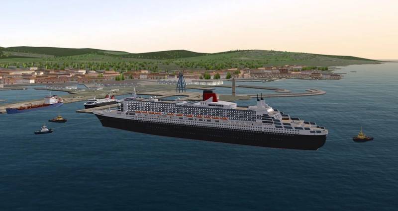
FORCE Technology has expanded its engineering design and testing services portfolio to provide remote access to high fidelity maritime navigation simulation for the purpose of testing planned port and harbor construction projects. The new SimFlex Cloud for engineering studies unlocks time and cost savings during the planning and design phase of maritime infrastructure projects as proposed developments can be evaluated in real-time and under highly realistic conditions without the requirement to visit a physical simulator facility.

SimFlex Cloud for engineering studies is an expansion of maritime simulator developer FORCE Technology’s latest generation SimFlex Cloud simulator, a dedicated SaaS (Software as a Service) solution offering highly realistic navigation simulation for training purposes. It expands the company’s established engineering design and testing services making them fully available online, helping customers to reduce costs and accelerate the planning phase by providing easy remote and real-time access to highly accurate environment simulations based on the proposed structural and/or vessel routing changes.

All new environmental model designs are created by FORCE Technology engineers within weeks of receiving the engineering plan so they can be quickly assessed by professional captains, pilots and navigators using any of the 700 mathematical ship models in the SimFlex Cloud vessel database. While FORCE Technology already provides engineering check-out services using its in-house simulators, SimFlex Cloud for engineering studies introduces the new possibility of immediate online access for testing at any time and from anywhere with a stable broadband connection.

Navigators and bridge officers charged with harnessing their real-life experience to verify the impact of port and harbour design changes can operate their vessel models using a mouse and keyboard, a specially designed operator console for desktop simulation and can even operate their vessels in the first person using SimFlex Cloud’s new Augmented Reality (AR) functionality. Further, SimFlex Cloud for engineering studies provides the capability to automate test routes and specific maritime operations in order to produce trustworthy data over continuously repeated activities.

SimFlex Cloud for engineering studies is a highly efficient way to verifying the impact of any new maritime infrastructure, from large turnkey projects to smaller more localized work. Design test applications include navigation in relation to new or removed seamarks; the effects of the design and location of piers including width and location of landing channels; conditions for arrival/departure in existing or new ports; vessel movements in relation to both frequency and time, which contributes to the precise assessment of e.g., the risk of grounding; moored ship movement at open or closed facilities; and maneuverability in shallow waters.

“Engineering design verification is a key service provided by the expert team at our state-of-the-art simulator facility in Kgs. Lyngby, Denmark,” said Jan Michelsen, Head of Department, Simulation, Ports & Training at Force Technology. “Providing online access to these services through the introduction of SimFlex Cloud for engineering studies is a natural step that will help to optimize our customers’ workflows and allow them to make the most of their infrastructure planning & design budgets. The system also enables us to support customers from further afield, as online access significantly reduces the need for firsthand time with our full-mission simulator.”

Source: https://www.maritimeprofessional.com/news/maritime-simulator-port-engineering-studies-379238


CREWEXPRESS STCW REST HOURS SOFTWARE - Paris and Tokyo MoU have announced that they will jointly launch a new Concentrated Inspection Campaign (CIC) on Standards of Training, Certification and Watchkeeping for Seafarers (STCW) from 1st September 2022 to 30th November 2022


Sperry Marine has partnered with Egersund, Norway-headquartered NAVTOR to launch Sperry Marine Navigation Charts and Voyage Planning.

Designed to optimize vessel safety and efficiency, the service provides an integrated e-navigation solution that reduces administration associated with chart updates and route planning and improves cyber security.

The service—the latest addition to the SperrySphere platform—leverages NAVTOR’s award-winning service, designed to reduce fuel costs, support compliance with environmental regulations and reduce workload for navigators by providing all critical voyage information in one integrated application.

The system analyzes the planned route and compares navigation data with the vessel’s water and air draft and other specifications to ensure full safety from berth to berth.

With databases and permits automatically distributed and updated seamlessly, the huge number of administration hours and the risk of human error during manual planning can be reduced.

The ENC chart service simplifies workflow for fleet managers and navigators and provides full control and accessibility over charts with Navtor’s NavTracker chart management and ordering tool. This enables shipowners to take advantage of a range of data subscription models, including PAYS (pay-as-you-sail), to meet each vessel’s specific needs.

The PAYS model enables shipowners to more accurately manage their purchases costs with no need to pay for unused charts.

Cyber security protocols are enforced by Sperry Marine’s Secure Maritime Gateway which uses multiple firewalls and a “demilitarized zone” as a staging post between front and back of bridge to ensure there is no direct connection between the navigation systems and the ship’s main IT network.

“We believe e-navigation is the future of shipping because we truly understand the problems of wasted time, unnecessary workload and lack of integration when using paper charts and manual voyage planning,” said NAVTOR managing director Tor Svanes. “This partnership with Sperry Marine will deliver an integrated solution, ensuring customers unlock the full potential of e-Navigation in a smart, safe and simple way.”

The Charts and Voyage Planning module is deployed and managed through the SperrySphere smart navigation platform. This is a one-stop-shop back-of-bridge digital platform which manages delivery of a wide variety of safety and voyage optimisation applications and a roadmap including remote support and diagnostics of navigation equipment.

“NAVTOR and Sperry Marine are global leaders in digital navigation solutions and by combining our expertise we can ensure that charts and routes can be securely and automatically updated using the Secure Maritime Gateway,” said James Collett, managing director, Sperry Marine. “We not only aim to improve the vessel’s cyber security performance; the SperrySphere will be the platform we use to deliver, smarter, safer digitally-enabled navigation to our customers.”


CREWEXPRESS STCW REST HOURS SOFTWARE - Paris and Tokyo MoU have announced that they will jointly launch a new Concentrated Inspection Campaign (CIC) on Standards of Training, Certification and Watchkeeping for Seafarers (STCW) from 1st September 2022 to 30th November 2022


The latest Sperry Marine Digital service, powered by NAVTOR, will reduce fuel costs, support regulatory compliance and reduce administrative workload for crew and shore teams

Sperry Marine, the Navigation Experts, has partnered with NAVTOR to launch Sperry Marine Navigation Charts and Voyage Planning. Designed to optimize vessel safety and efficiency, the service provides an integrated e-navigation solution that reduces administration associated with chart updates and route planning and improves cyber security.

Navigation Charts and Voyage Planning is the latest service addition to the SperrySphere platform, leveraging NAVTOR’s award-winning service, designed to reduce fuel costs,  support compliance with environmental regulations and reduce workload for navigators by providing all critical voyage information in one integrated application.

The system analyses the planned route and compares navigation data with the vessel’s water and air draught and other specifications to ensure full safety from berth to berth.

With databases and permits automatically distributed and updated seamlessly, the huge number of administration hours and the risk of human error during manual planning can be reduced.

The ENC chart service simplifies workflow for fleet managers and navigators and provides full control and accessibility over charts with NAVTOR’s NavTracker chart management and ordering tool. This enables shipowners to take advantage of a range of data subscription models including Pay-As-You-Sail, to meet each vessel’s specific needs.

The PAYS model enables shipowners to more accurately manage their purchases costs with no need to pay for unused charts. Cyber security protocols are enforced by Sperry Marine’s Secure Maritime Gateway which uses multiple firewalls and a ‘demilitarised zone’ as a staging post between front and back of bridge to ensure there is no direct connection between the navigation systems and the ship’s main IT network.

“We believe e-Navigation is the future of shipping because we truly understand the problems of wasted time, unnecessary workload and lack of integration when using paper charts and manual voyage planning,” said Tor Svanes, Managing Director, NAVTOR. “This partnership with Sperry Marine will deliver an integrated solution, ensuring customers unlock the full potential of e-Navigation in a smart, safe and simple way.”

The Charts and Voyage Planning module is deployed and managed through the SperrySphere smart navigation platform. This is a one-stop-shop back-of-bridge digital platform which manages delivery of a wide variety of safety and voyage optimisation applications and a roadmap including remote support and diagnostics of navigation equipment.

“NAVTOR and Sperry Marine are global leaders in digital navigation solutions and by combining our expertise we can ensure that charts and routes can be securely and automatically updated using the Secure Maritime Gateway,” said James Collett, Managing Director, Sperry Marine. “We not only aim to improve the vessel’s cyber security performance; the SperrySphere will be the platform we use to deliver, smarter, safer digitally-enabled navigation to our customers.”

Source: https://xindemarinenews.com/en/market/2022/0823/41196.html


CREWEXPRESS STCW REST HOURS SOFTWARE - Paris and Tokyo MoU have announced that they will jointly launch a new Concentrated Inspection Campaign (CIC) on Standards of Training, Certification and Watchkeeping for Seafarers (STCW) from 1st September 2022 to 30th November 2022


CIRM Guideline to combat ECDIS operational issues

International association of marine electronics companies, Comité International Radio-Maritime (CIRM) has published its Guideline on Performance Test Procedure for ECDIS to minimise operational issues of ECDIS systems.

According to CIRM, stakeholders have raised concerns about the condition on in-service ECDIS. Operational issues include inadequate power supply arrangements, the running of outdated software versions, disabled audio signal for alerts, and the incorrect functioning of interfaces to connected equipment, among others.

CIRM developed the Guideline in response to these concerns. The Guideline outlines a test procedure to be carried out on a ship’s ECDIS installation, to determine if the ECDIS meets the operational requirements defined by the IMO. It describes a range of manufacturer-recommended tests and checks, which correspond to IMO’s requirements for ECDIS as laid down in SOLAS regulations.

The Guideline was produced by CIRM’s ECDIS Working Group, with the input of ECDIS manufacturers, system integrators, and service providers.

Ultimately the purpose of the Guideline on Performance Test Procedure for ECDIS is to ensure that an in-service ECDIS is functioning properly, in the interests of safety of navigation.

CIRM’s secretary-general, Frances Baskerville said: “We are very pleased that CIRM members have come together to develop a practical solution to industry concerns about the operational condition of ECDIS. This new Guideline will provide stakeholders with effective measures to identify and address ECDIS operational issues. ECDIS is a key navigational tool and it is therefore essential that systems function as IMO intended.”


SOURCE LINK OF ARTICLE


maritime cyber security Kongsberg Maritime director of autonomy Peter Due explains why e-navigation and technology developed for the Yara Birkeland project will enable a future of autonomous shipping

ECDIS and e-navigation will be essential for generations of future autonomous ships. Although the first unmanned ships will be remotely controlled and operating in coastal waters, in the long term there will be ocean-going autonomous ships, with e-navigation technology monitoring their progress onshore.

IMO placed ocean-going autonomous vessels firmly on the global agenda during the Maritime Safety Committee (MSC) 99 session in May this year, by implementing a working group to conduct a regulatory scoping exercise for using MASS (Maritime Autonomous Surface Ships)*.

Kongsberg Maritime will be part of that working group and will deliver technology to the world’s first all-electric, zero emissions and autonomous container vessel, Yara Birkeland. This ship is scheduled to transport fertiliser products along a 30 nautical mile route to the ports of Brevik and Larvik next year and by 2020 is likely to be unmanned.

Kongsberg Maritime director of autonomy Peter Due said new navigation and collision avoidance systems that centre on e-navigation technology were needed for this project, as Yara Birkeland will operate on a busy waterway.

Kongsberg drew on its experience in autonomous underwater vehicles, dynamic positioning, ECDIS and sensor fusion as a foundation for autonomous navigation. But Mr Due explained to Marine Electronics & Communications that more development was required. “Harmonising with artificial intelligence, machine learning and digital twin technology enables the extreme level of safety required,” he said.

Mr Due said Yara Birkeland’s operations will be planned, pretested and optimised in the cloud using the Kognifai digital platform and its digital twin that Kongsberg generated. This includes navigation in different metocean conditions.

“The twin integrates all data including weather, currents, tides and temperature with a detailed physical ship model,” said Mr Due. “We can then decide the optimum route and simply transfer it to the ship’s autonomy engine, navigation systems and ECDIS when it is in port,” he continued.

“Once the ship sets off, sensor fusion comes into play, enabling the autonomy engine, working with the onboard digital twin and e-navigation systems to adjust and reroute at sea according to the going conditions and other vessels in the vicinity.”

It is this dynamism a fully autonomous navigation system requires that led to the establishment of the Hull to Hull (H2H) EU-funded research project. This will develop technical solutions for safer navigation in close proximity of other stationary or moving vessels and objects.

H2H will use the European Global Navigation Satellite System to enhance safety in busy waters and during close manoeuvring. “This will help mariners to make the correct navigation decisions and will create the fundamental conditions for autonomous vessel navigation,” said Mr Due. Data can be used as an input to an autonomy controller.

Navigational safety is essential if the benefits of MASS are ever to be truly realised”

Ensuring e-navigation and collision avoidance technology works correctly will be fundamental to autonomous shipping. “Navigational safety is essential if the benefits of MASS are ever to be truly realised,” said Mr Due.

SOURCE READ FULL ARTICLE


ECDIS POLICY MANUAL

The Electronic Chart Display and Information System (ECDIS) is a development in the navigational chart system used in naval vessels and ships.
With the use of the electronic chart system, it has become easier for a ship’s navigating crew to pinpoint locations and attain directions.

The introduction of ECDIS is the most significant change to have occurred in marine navigation in recent years, with a wide range of vessel types and sizes affected by the SOLAS ECDIS mandate.​​

This mandatory carriage of ECDIS has been put in place to help improve the safety and efficiency of marine navigation through heightened awareness and the automation of
time-consuming navigational tasks.
To meet this mandate, ships must have fitted ECDIS on board ship before the dates outlined in the International Maritime Organization’s (IMO) rolling timetable.​


Very common observation during vetting by Oil Companies Inspectors in our days is that INSUFFICIENT INFORMATION IN THE SAFETY MANAGEMENT SYSTEM (SMS) ON THE OPERATION OF ECDIS .

We have develop a Manual that will help you implement ECDIS requirements and be in compliance with all in force requiremets :

Content

– Company’s Policy while using ECDIS,
– Legislations
– Mandatory ECDIS requirements
– Risk Assessments ( Method , Areas and Assessment Process )
– Training
– Familiriazation
– Use of ECDIS
– Passage Planning and Route Planning
– Maintenance
– Charts updating
– Forms
– Records

ETC.

In full compliance with national and international regulations.

Approval by the Administration or a Recognised Organisation (RO) on behalf of the Administration is NOT mandatory.

We offer the manual in WORD EDITABLE FORMAT and no consultancy being offered from our end for further implementation.

ONLY EURO 500 !!

SHIP IP Ltd

| T: ( +30) 211 850 1121
| e: sales@shipip.com
| w: http://localhost/shipip
| Skype : anyawb1

24/7 Email support – Best Network of inspectors – SHIP IP LTD – Shipping Virtual Services – Since 2013