Five people were successfully ejected and two lost their lives in an unforeseen boat collision in the Texas Gulf near Freeport on 6 August, per the US Coast Guard. The boat reportedly collided head-on, officials mentioned.

The fatal crash took place around 9:15 p.m. when an individual who was operating a 22-foot boat ended up colliding with a 24-foot vessel between Mile Markers 382 and 384 in the waters of Gulf Intracoastal Waterway. Officials mentioned that the boater and three guests were going northbound when they rammed into the 24-foot vessel that was headed southbound.

Per the Coast Guard, three passengers were reportedly ejected from the 22-foot boat, as were the two individuals, a husband, and his wife, on the 24-foot vessel. Two passengers from the 22-foot boat could get to the other vessel and they climbed aboard.

When the crews reached, they discovered an unresponsive woman’s body from the 24-foot vessel. After the Coast Guard crew took aboard the body and continued the search, they located a third survivor who was successfully ejected from the 22-foot vessel. The person was conscious and suffered a minimal head injury.

boat collision

Sometime around midnight, the Gulf Coast Rescue Squad members were able to locate the other boater who was thrown from the pleasure craft, a non-responsive male. The Coast Guard crew took aboard the person’s body and brought the two deceased individuals and other survivors to Surfside Marina based in Freeport. Emergency medical services staff examined the survivors and extended care to the two men who suffered minor injuries, per the Coast Guard.

Although the case did not quite end the way they had desired, with all boaters unharmed and safe, they are thankful that the team’s hard work with agency and commercial partners helped assist the survivors quickly, Jeremy Borja the Chief Warrant Officer 3, command duty officer associated with Sector Houston-Galveston, mentioned. He added that they offer heartfelt sympathies to the family of the two boaters who were unable to make it and wish them healing in the wake of the tragedy.

Both the vessels are aground and anchored close to Mile Marker 382. Personnel of the Texas Parks and Wildlife Department are conducting a thorough of this incident.

References: Click2Houston, Houston Chronicle


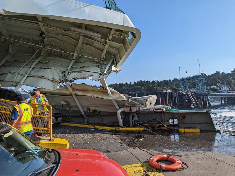
Washington State Ferries said one of its vessels suffered “significant damage” as the result of a “hard landing” at the Fauntleroy terminal in Seattle on Thursday.

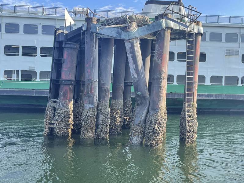
The Cathlamet, which was traveling from Vashon Island to West Seattle during a 7:55 a.m. sailing, reportedly struck an offshore dolphin (pilings, not the aquatic mammal) before alliding with the dock.

Photos shared to social media show considerable damage to Cathlamet’s port bow above the waterline. No injuries or pollution were reported, though several cars on board the ferry have been damaged. All but two cars were able to exit the ferry, according to the U.S. Coast Guard.

The Coast Guard said it is working with Washington State Ferries to investigate the cause of the incident.

Meanwhile, the Fauntleroy terminal is closed until further notice. “The dock structure will be examined and if it’s determined to be usable, we’ll restore service there,” Washington State Ferries said.

The state ferry operator said it is working with Kitsap Transit and King County Metro to coordinate passenger-only services while its Fauntleroy service is affected.

Cathlamet is a 328-foot Issaquah class ferry with capacity for 1,200 passengers and 124 vehicles. It was built by Marine Power and Equipment in Seattle in 1981.

(Photo: U.S. Cost Guard)

(Photo: Washington State Ferries)

Source: https://www.marinelink.com/news/ferry-damaged-hard-landing-seattle-498376


A crew member reported missing from a Chinese bulk carrier, off the coast of Geraldton, has been found alive and well in the water.

The man, aged in his 30s, walked off a rescue boat wrapped in a blanket and into a waiting ambulance.

Western Australian police and border force officers were on hand during the transfer.

The Chinese national was taken to Geraldton Regional Hospital for medical assessment.

Man wrapped in blanket sets onto ambulance
The man walks to a waiting ambulance, at the port in Geraldton.(ABC Midwest Wheatbelt; Rachael Clifford)

Authorities were first notified of the missing crew member about 6.40pm yesterday.

The Chinese bulk carrier ship was anchored 11 kilometres off the Geraldton coast at the time.

An initial air and land search coordinated by Australian Maritime Safety Authority (AMSA) involving a jet was carried out last night, but did not find the man.

Volunteer and career search crews were deployed, including an AMSA jet at first light.

A search vessel found the man about 24km north-west off the Geraldton coast at 8.40am today.

Source: https://www.abc.net.au/news/2022-07-25/missing-chinese-sailor-found-alive-in-waters-off-geraldton/101266662


Since late last month, about 100 sub-contractors pressing for an increase of 30% have occupied the main dock at the shipyard run by Daewoo Shipbuilding & Marine Engineering (DSME) in the southern city of Geoje.

The shipyard is one of the world’s biggest and the strike has led to delivery delays of eight vessels by as much as five weeks, just as the global shipbuilding industry is signalling a rebound.

Orders have come in as European countries rush to ramp up liquefied natural gas (LNG) deliveries to replace Russian gas supplies in the wake of the Ukraine crisis.

Union officials accepted an offer of a 4.5% wage increase and a promise of job guarantees for workers at some subcontracting firms that may be closing, a union official told reporters.

South Korea’s labor minister Lee Jung-Sik told a briefing that the agreement sets an important precedent for resolving labour-management disputes, adding that the government hopes that labour-management culture based on laws would be established in the future.

More than 90% of the striking workers agreed to accept the deal, though “No one in the union is satisfied with the tentative agreement,” another union official said.

The agreement reached on Friday also leaves open the possibility of legal action against the contract workers to recover damages after they occupied the dock during the strike.

“Concerning problems that arose from the strike process, we will respond in accordance with the law and principles,” Daewoo Shipbuilding said in a statement.

The strike was the second major industrial dispute for the government of President Yoon Suk-yeol who took office in May, after a truckers’ strike in June ground the country’s major industrial facilities and sea ports to a halt.

It came as the latest challenge for the conservative president who has promised business-friendly policies but has grappled with record inflation, affecting some of the lowest paid workers in the country the most.

Yoon had called the strike at Daewoo illegal and hinted the police may be sent in to break it up by force. Read full story

Daewoo has previously said it expected a daily loss of 32 billion won ($24 million) from the strike, adding that the dispute had cost it more than $400 million by mid-July.

“We will put all our capabilities into making up for delayed production, and work harder for a co-operative co-existence with subcontractors,” Daewoo Shipbuilding added in a statement.

Source: https://www.marinelink.com/news/south-korean-shipyard-workers-end-strike-498249


At the recent Quad leaders’ summit in Tokyo, Australia, India, Japan and the US launched the Indo-Pacific Partnership for Maritime Domain Awareness, an initiative aimed at strengthening maritime security in the region. Apart from one very useful explainer and David Brewster’s excellent recent analysis, the announcement has been largely overlooked.

The objective is for regional countries to buy commercially available satellite tracking data of ships and combine it with data gathered from sources such as automatic identification systems, which broadcast a ship’s name, location, course, speed and other data.

‘This initiative will transform the ability of partners in the Pacific Islands, Southeast Asia, and the Indian Ocean region to fully monitor the waters on their shores and, in turn, to uphold a free and open Indo-Pacific,’ a White House fact sheet noted.

However, ‘fully’ is somewhat of an overstatement; it would be more realistic to say that it would provide another means for countries to monitor their waters. It would provide unclassified data, and its principal customers would be civil maritime law enforcement agencies, especially coastguards and maritime police.

As Brewster explained, one of the biggest challenges for small countries in the region is tracking suspected illegal fishing vessels that ‘go dark’ by switching off their automatic identification systems. That’s not possible with vessel monitoring systems: if they’re installed as a term of licence, they can’t be tampered with in the same way, and if they’re turned off they send a notice. Automatic identification systems have no such functionality, since they’re designed for safety of navigation and not for monitoring. The Quad initiative would therefore be another very useful data source for agencies cracking down on illegal fishing and a valuable feed for more efficient enforcement activities using surveillance aircraft and surface vessels.

In building the system, much can be learned from the Pacific, where the island states face a pressing need to understand more about what’s happening in the waters that surround them. The small island nations have developed sophisticated platforms like the fisheries information management system, which houses all industry, observer, registry, licence, compliance, catch documentation, certification, vessel monitoring and other data and manages it on a single secure platform. From this base, the fishery can be sustainably managed and (where agreed) data fields are forwarded in near real time back to sovereign nations; fishing and market states; and industry, science, surveillance, compliance and regional fisheries bodies such as the Forum Fisheries Agency surveillance centre in Solomon Islands. It holds a common operating picture based on data provided through member states’ vessel monitoring systems, some high-seas data from the Western Central Pacific Fisheries Commission, and data from ships’ automatic identification systems and long-range tracking and identification systems.

One area in which the Quad partners should consider applications for the new system is the Indo-Pacific’s southern flank: the Southern Ocean and Antarctica. The Quad countries are all active Antarctic players. But the southern Indo-Pacific boundary often gets neglected in discussions.

The ship-tracking data from the plethora of satellites in low-earth orbit (particularly polar orbits) is just as applicable to the Southern Ocean as it is to the high latitudes of the Indian and Pacific Oceans. There’s no significant technical reason why this data wouldn’t be available to go into the shared analysis and distribution network that’s envisaged through the Quad.

It would be worth the Quad partners thinking about three potential zones of the Southern Ocean where the system might operate: the temperate region, north of the polar front and up to the continental margins of Australia, South Africa and South America; the sub-Antarctic region, north of 60°S and south of the polar front; and the Antarctic Treaty Area, south of 60°S.

For the first zone, leveraging the system into that area makes good sense. It would be of obvious military, fisheries and search-and-rescue benefit to all states bordering the Southern Ocean.

For the second zone, there may be some concerns about extending it into the area protected under the Convention on the Conservation of Antarctic Marine Living Resources, albeit above 60°S. At the moment, the convention doesn’t expressly provide for aerial inspections (although the Antarctic Treaty does under Article VII), so there’s some argument among members about whether data collected in this way (or further data collected by satellite) can be used to support inspections under the convention.

That was the issue with the Russian vessel FV Palmer, which was spotted by a New Zealand military aircraft while apparently fishing in an area closed to fishing, some 800 nautical miles from where the vessel was officially reported to be. Both Russia and China disputed that data collected from aerial patrols was allowable under the convention’s inspection system. Information collected from the Quad system would likely face similar resistance from these states if someone attempted to use it as evidence of an inspection under the convention. But at the very least, the data could be used as intelligence to support the well-established practice of vessel-based inspection under the convention.

For the third zone, there’s the possibility of negative perceptions in some states arising from the non-militarisation provisions in Article 1 of the Antarctic Treaty. Extending the system into the Antarctic Treaty Area could generate concerns that the Quad was somehow ‘securitising’ the region and acting against the spirit of the treaty’s demilitarisation provisions.

But the counterpoint to those concerns is that maritime domain awareness for civilian purposes is a ‘peaceful use’. The Antarctic Treaty inspection regime expressly allows for ‘aerial inspection’ of stations and ships in the treaty area. That might arguably include satellite inspection from space.

It’s not clear yet who will put the system together and provide intelligence to regional information centres and national law maritime enforcement authorities. Presumably Maritime Border Command—a multi-agency taskforce in the Australian Border Force that coordinates surveillance of and responses to civil maritime threats, such as illegal fishing—will play a role.

It may turn out that there are just too many cooks in the kitchen. But in theory, the Indo-Pacific Partnership for Maritime Domain Awareness is a promising idea to bolster the maritime security of the region, including the Southern Ocean, by creating a networked real-time picture that allows for a shared understanding of threats and developments in the maritime domain.

While not a complete solution in its own right, the data from the system, correlated appropriately and delivered in a timely manner, will be another valuable input to the many other initiatives seeking to provide more effective maritime domain awareness in the region.

SOurce: https://www.aspistrategist.org.au/quad-maritime-security-initiative-holds-promise-for-the-indo-pacifics-southern-flank/

The first initiative launched is the opening of its new Centre for Maritime Efficiency (CME). The key role of CME is to enable PIL to grow its competencies in managing ship and fleet energy-efficiency performance.

The CME’s responsibilities include traffic optimisation and route analysis aimed at minimising energy usage by PIL’s fleet.

The CME will be equipped with a digital system that houses all relevant operational data and applications in a single platform to facilitate comprehensive, centralised and efficient coordination.

With the new CME, PIL will be able to: reduce greenhouse gas (GHG) emissions generated from its operations; enhance fleet safety and security; maximise cost-effectiveness through efficient traffic and route-based management of PIL’s fleet; and improve provision of more training berths for seafarers and creating a bridge for a ship-to-shore career path.

Lars Kastrup, new CEO of PIL, said: “The rolling out of this new Centre for Maritime Efficiency is timely as we forge ahead to become a more efficient shipping line committed to reducing our carbon footprint.

“This is also aligned with our aim to better leverage technology and digitalisation in our operations for enhanced operational effectiveness. At the end of the day, we aim to deliver quality service and good connectivity to our customers, who are increasingly expecting container shipping services to be nimble and flexible to meet their evolving needs.”

PIL has also signed Memorandum of Understanding (MoU) with Singapore Polytechnic’s Centre of Excellence in Maritime Safety (CEMS) to collaborate on a ‘Training with Technology’ project.

This project aims to leverage the latest technologies to enhance the competency of seafarers in safe navigation through technical and soft skills training.

PIL and CEMS will jointly explore the effectiveness of using immersive, simulation and remote technology to deliver safety-related and ship navigation training in demanding traffic and sea states.

The data and knowledge collected from this project will be utilised for research and collaboration between the two partners towards the objective of strengthening the standards of maritime safety.

Source: https://www.porttechnology.org/news/pil-launches-initiatives-to-enhance-efficiency-and-safety/


The Accident

On December 1, 2020, the crew of the bulk carrier Blue Bosporus were carrying out a free-fall lifeboat drill at anchor in English Bay, British Columbia. After the four wire rope slings for lowering away the free-fall lifeboat were attached, the third mate and an AB went aboard the boat to conduct a test launch. The third mate activated the release hook, and the lifeboat slid forward about 25cm. At that point, three slings connecting the boat to the davit failed, along with the bracket connecting to the fourth sling. The boat fell 45 feet into the water.

Both crewmembers aboard were seriously injured – one with leg injuries and one with an injured hand – and they were taken to a hospital for treatment. The boat’s hull sustained damage where it struck the water. Most (but not all) of the broken sling components were retrieved for analysis. 

A post-accident investigation found that the crimp sleeves on the slings had weakened over time due to stress corrosion cracking – a common problem for stainless steel. In addition, one of the slings was shorter than the others, meaning that it took the full load of the boat when the hook was initially released. This sling failed first, followed by the others in sequence.

The crew were under orders to exit the lifeboat after releasing the hook, before the boat was lowered into the water using the davit – a practice consistent with IMO guidance.

However, they still needed to be present in the boat in order to release the hook. They were in the practice of standing without securing themselves to the seats while carrying out this task. “There had been no assessment of the risk associated with standing unsecured in the lifeboat when it was suspended by its slings,” TSB concluded.

The vessel’s maintenance schedule did not specifically cover inspecting the condition of the slings, according to TSB. After the casualty, the shipowner installed new load-tested sling assemblies and brackets, and it sent a safety circular to update its requirements for lifeboat inspections and drills.

Source: Canada Transportation Safety Board (TSB)


That will be used to support updated nautical charting and improved coastal zone management. The project is a key initiative contributing to Papua New Guinea’s sustainable economic development.

To accomplish the work, the Fugro LADS HD+ Airborne Lidar Bathymetry (ALB) system was deployed with a team of surveyors from both the NMSA and Fugro working in collaboration. Fugro’s ALB system meets International Hydrographic Organization (IHO) standards with the data now set to be used to update nautical charts. The data was collected safely and with minimal environmental impact on the sensitive reef environment or local marine activity.

Through this Maritime and Waterways Safety Project, Fugro has successfully worked with the NMSA and ADB to help deliver both hydrographic data and training of NMSA staff. The project aims at improving the safety and efficiency of international and national shipping in coastal areas and waterways of Papua New Guinea by improving maritime safety information infrastructure and practices and capacity. Safer maritime activities that improve trade and tourism, as well as information to help manage the environment, will bring direct benefit to PNG’s coastal communities

Paul M. Unas, the CEO of NMSA was pleased with the successful outcome of the Star Reefs Passage Survey under the Asian Development Bank-funded Maritime and Waterways Safety Project and reaffirmed NMSA’s Commitment to ensuring the PNG navigable waterways are adequately surveyed to IHO specifications and nautical charts are updated for the safety of navigation. Mr Unas thanked Fugro for LADS HD & ALB systems performance and capability to meet NMSA expectations in time-demanding environments.

Paul Seaton, Director for Hydrography and Coastal Resilience added that Fugro was very proud to work with the NMSA team who played a key role in both project planning and collecting the data. The collaboration was a great example of how this work can contribute to the develop local capabilities to deploy innovative technologies to manage the marine environment.

Source: https://www.marketscreener.com/quote/stock/FUGRO-N-V-6396/news/Fugro-N-and-National-Maritime-Safety-Authority-improve-Papua-New-Guinea-s-navigation-safety-40959976/?utm_medium=RSS&utm_content=20220712


Norwegian Cruise Line is curtailing one of its cruises after its cruise ship Norwegian Sun had a rare encounter hitting a smaller piece of ice over the weekend while traveling in Alaska. The 78,000 gross ton cruise ship suffered unspecified damages that have forced the ship to skip ports on its current cruise and cancel the next cruise to undergo repairs.

With visions of the ill-fated Titanic being invoked, passengers are reporting Saturday morning they awoke to feel a shudder in the ship. The Norwegian Sun was cruising north of Skagway in the Gulf of Alaska toward a scenic visit to Hubbard Glacier and was encountering fog, which is typical of the region. A spokesperson for Norwegian Cruise Line reports that the cruise ship “made contact with a growler,” typically a smaller chunk of ice defined to be no more than about six feet in length. They typically have broken away from a larger formation and are low to the surface of the ocean making them especially difficult to see from the bridge. The majority of their mass is below the water and often the water can be washing over the top of the chunk of ice.

It is unclear what speed the cruise ship was traveling, but a video posted to social media by passengers shows a large black formation of ice floating in the water larger than the typical growler. The contact was along the forward starboard side of the vessel and the ice can be seen floating past the cruise ship.

Passengers reported that the cruise ship was moving slowly after the encounter with the ice. Later the Norwegian Sun changed course, canceling the planned call at Hubbard Glacier and a port visit scheduled for Skagway, Alaska on Sunday. The cruise ship traveled south arriving in Juneau, Alaska later on Sunday, where an inspection was carried out to determine the extent of the damage.

“The ship was given clearance by the United States Coast Guard and other local maritime authorities to return to Seattle at reduced speed,” said the spokesperson. Passengers reported they departed Juneau late Monday and the current AIS signal shows the ship traveling at approximately 16 knots saying its destination is Victoria, Canada. This, however, could be a technical call to meet the requirement to visit a foreign port as Norwegian is reporting that all guests currently onboard will disembark in Seattle as originally planned.

The Norwegian Sun had departed from Seattle on June 21 on a nine-night cruise. They had visited Sitka, Alaska and Icy Strait Point, before heading toward Hubbard Glacier. Port calls at Skagway and Ketchikan in Alaska were canceled when the cruise was curtailed and the vessel began its return voyage. The next cruise of the Norwegian Sun scheduled to depart on June 30 from Seattle has also been canceled so that the necessary repairs can be made to the ship.

Encounters with smaller pieces of ice are common in Alaska when the cruise ships are sailing at slow speeds mostly near the glaciers. The ice occasionally bumps against the hull typically not causing any damage. The location of this encounter, the size of the growler, and the speed of the ship however appeared to have conspired to a unique set of circumstances, and the first reported incidence where a modern cruise ship was damaged and forced to cancel cruises due to hitting an iceberg.
Source: https://www.maritime-executive.com/article/video-norwegian-sun-curtails-cruise-after-hitting-ice-in-alaska


Company DETAILS

SHIP IP LTD
VAT:BG 202572176
Rakovski STR.145
Sofia,
Bulgaria
Phone ( +359) 24929284
E-mail: sales(at)shipip.com

ISO 9001:2015 CERTIFIED